 We started off with early Albany, with some great maps of the city in 1695 and moving through the years to see the progression of the edges of the city, and the outlines of features like the stockade and where development was planned out.
 |
| Albany 1695 |
Of course, you'll need to remember a key detail when reading such older maps of the area. Because this is just how we are in New York, maps aren't as expected - north is not at the top of the maps. Instead, as Tony pointed out, the Hudson River is always on the bottom of these older maps like the one shown here.
We saw a bit of the architecture of these buildings, including the residential as well as the industrial buildings. Tony had interesting photos of buildings that were part of Albany's industrial area. Although, often times as Tony explained with these images, the industry area was the same as the residential area, with some businesses actually moving into what had originally been designed to be a residential building.
Here's a sample of industries in Albany that he shared with us:
 The image on the bottom left is one of those examples of a residential building becoming repurposed for business (sort of like the apartments that seem to be cropping up in old factories and mills, but in reverse!) The playful scene of children enjoying a day out on the local swing set has an additional layer to its story when you think about what Tony shared with us about the building in the background - one of those industries that was probably sharing more than just a block with that playground. Regulations on waste disposal wasn't quite the same as today....
As Tony explained throughout the lecture, the city developed in the ways it did for overlapping reasons as buildings were constructed or repurposed or, as we would see through more images of later Albany, areas were demolished to make way for a different set of plans. Tony explained the changing groups of immigrants to Albany - from the original Dutch and then English, the German and Irish immigrants, and the Italians and Eastern Europeans. Looking at this picture is a great example of seeing the change in immigrants through businesses - this one has a sign (not the Junk Shop although that would've had some interesting items in it...) that appears to read " Kinckel" , advertising ales and lager.

We were able to explore a little more of the community in these areas through some great photos of daily life like that of Green Street in the 1920s with another image of children playing in the street.

Tony took us through the South End with all sorts of buildings, pointing out the ones that were still standing. Others were of buildings still waiting for a new use like the old St. John's church Tony's mother used to attend. We were able to see the development of the city through images of before and after urban renewal projects or to adapt to changing transportation methods. These were some fantastic before and after scenes of Albany.
 |
| South Ferry Street at Dongan Avenue in the 1930s and today |

Some of these changes were due to planned developments, but others like the one Tony is pointing to in this picture have a more amusing story. This building was once a church but when the roof was damaged, it was completely redone so that the pediment of this Greek revival building stayed missing along with the bell tower to make the front façade you see in the photo.
Here's a photo that is one of Tony's favorites based on the feature he's pointing to in the foreground. Some audience members gave a few good tries to identify it, which turned out to be one of the trolley poles that were along the streets when trolleys regularly made their way up and down the streets.
 |
| Hamilton Street in the 1930s - trolley pole and rails Eagle Street in the 1980s |


You can really notice the significant change in the layout of the city with some of these views of the South Mal area - notice the Capitol building in the background of the bottom image.
 |
| An aerial view of Albany pre-urban renewal |
One of the other interesting features of urban development that Tony shared with us is the cyclical nature of some of the projects. The earlier plans included removing the rows of houses to construct the large towers for people to live in those apartments. But it was quickly learned that this plan was not the best for housing the families that lived in the area they were built in, moving back towards constructing the row houses that he shared in some of the more recent photos of the area.
This photo shows one of the advantages of the many changes over time to the city. This is an image of Green Street again, in 1936, which is one of the last flood Albany experienced in that section of the city.

But with time, the history of the city was taken into consideration more when development was put into place thanks to the New York State Preservation Act of 1980. Tony shared his own trip to check out one of the excavations that occurred as construction was planned for where the 77 Prime Building stands, which was the site of discovery for the giant rum vats at the New York State Museum. The excavation of the old Fort Orange was a big draw for both tourist and native as they uncovered more of Albany's Dutch history that had been lost in earlier demolitions and constructions in the area.
Tony shared another of his memorable pictures with us - this time for more personal reasons. He and our board member Kevin Millington worked together in the Department of Housing and Urban Development and were familiar with this building.
 Tony's mother attended this school where she learned English in kindergarten. Efforts were made to assess the property but the ceiling had decayed and ultimately the building was demolished. An open park area is what is on the site today, although Tony is sure that tree has to be more than 30 years old...some fun speculation about incorporating living trees into your building design followed...
But some things will always be the same even as the buildings changed. Albanians will always find ways to have fun with each other - here's a few shots of Lincoln Park when it opened in the 1930s. Before the Empire State Plaza was built and the pools there were frozen over in the winter, Lincoln Park was flooded and ice skating was a treat during the winter!
 |
| Lincoln Park during the summer 1930s |
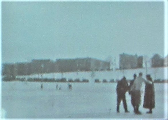 |
| Ice Skating on the frozen pool in Lincoln Park in the winter 1930s |
The South End of Albany is definitely a melting pot of all the cultures that have - and continue - to make it their home. And its urban development projects are a piece of history as well, adding another piece to a fascinating discussion on Albany.
 We had a lively question and answer section of our lecture as well! It's great to see so many people interested in exploring local history! We'll be making the trip back to Waterford with our final lecture on March 14 at the Van Schaick Island Country Club (check out one of the delicious options you can order while you're there).
Hope to see you all there for an awesome close to our lecture series!
No comments:
Post a Comment